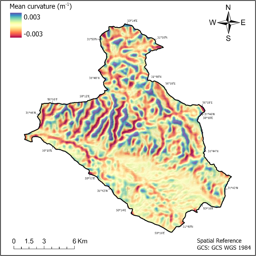
GEOMORPHOMETRY TOOLBOX · Version 1.0 for ArcGIS Pro
The Geomorphometry Toolbox executes all differential geometry and flow-routing algorithms directly on the reference ellipsoid of revolution (WGS 1984). This framework facilitates the direct derivation of local and nonlocal morphometric variables from spheroidal equal angular DEMs, entirely precluding the need for data reprojection and interpolation, while effectively mitigating latitude-dependent geometric distortions.
The Fundamental Paradigm
Standard global elevation models (e.g., SRTM, ASTER GDEM, and AW3D30) are inherently disseminated as spheroidal equal angular grids. Within this geometric framework, the angular spacing remains constant, whereas the physical dimensions of the grid cells (measured in linear units) are strictly latitude-dependent, progressively diminishing from the equator toward the poles. Conversely, traditional GIS algorithms are predicated on Euclidean geometry and plane square grids. The direct application of these square-grid methods to spheroidal equal angular DEMs introduces fundamental geometric inconsistencies and systematic computational errors in the approximation of the partial derivatives of elevation.
Abstract
Input DEMs are processed strictly within their native Geographic Coordinate System (GCS). All differential geometry and flow-routing algorithms are executed directly on the reference ellipsoid of revolution (e.g., WGS 1984).
Moving beyond the conventional 3×3 neighborhood, this approach fits a 10-parameter continuous surface over variable spatial extents (minimum 5×5) to effectively suppress high-frequency topographic noise and facilitate true multi-scale analysis.
This engine integrates three fundamental flow-routing algorithms (D8, MFD, and D-Infinity), coupled with intelligent topological management of flat surfaces and latitude-dependent effective contour width corrections—ensuring the precise calculation of Catchment Area (CA), TWI, SPI, and the LS-factor.
Computational Engine
Rather than relying on discrete finite-difference approximations between adjacent grid cells, a continuous, differentiable mathematical surface is fitted across each local neighborhood via ordinary least squares. The partial derivatives of elevation are then analytically derived from this surface to compute precise local morphometric variables.
Deriving a 10-parameter polynomial surface model using only 9 grid nodes from a conventional 3×3 window creates an underdetermined, mathematically ill-posed system. By establishing a minimum 5×5 window, the calculation encompasses 25 spatial nodes. This provides 15 degrees of freedom, creating an overdetermined system that enables Ordinary Least Squares (OLS) optimization to robustly fit the surface and effectively suppress high-frequency topographic noise.
Prior to constructing the design matrix, geodesic distances are normalized relative to the maximum neighborhood extent. This critical geometric scaling mitigates matrix ill-conditioning, ensuring robust inversion and numerical stability across extensive analytical windows.
The moving window dimension explicitly defines the physical scale of the terrain analysis. For instance, on a 30-meter SRTM DEM, a 5×5 neighborhood encompasses a 150×150 meter spatial extent; on a 1-meter LiDAR grid, the identical analytical window captures a highly localized 5×5 meter footprint.
At raster boundaries or adjacent to NoData regions, if a minimum of 15 valid grid nodes remain within the local neighborhood, the design matrix is dynamically reconfigured and inverted for that specific asymmetric spatial mask. This mathematically rigorous treatment minimizes edge artifacts and ensures maximum data retention.
Rather than acting as a conventional spatial filter, the window dimension explicitly dictates the physical scale of the morphometric analysis. To preserve geometric symmetry around the central grid node, its value is strictly constrained to odd integers, establishing a minimum 5×5 baseline to ensure mathematical stability.
The Geomorphometry toolbox is distributed as a standard ArcGIS Pro toolbox (.atbx). It eliminates the need for complex standalone installations, external dependencies, or Python environment configurations.
* Zero mandatory external dependencies. Core mathematical and topological operations run natively using the standard ArcGIS Pro Python environment (arcpy, numpy, scipy). numba and gdal are automatically engaged if present to deliver extreme multi-threaded performance and BigTIFF chunking.
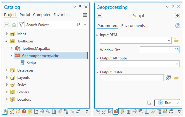
Geomorphometry.atbx inside ArcGIS Pro Catalog and Geoprocessing Panes
Rather than relying on an assumed planar constant, the true geodetic area of each grid cell is analytically computed as a spheroidal trapezoid. This engine integrates three fundamental flow-routing algorithms (D8, MFD, and D-Infinity) with a rigorous topological treatment of flat surfaces via the Garbrecht–Martz (1997) double-gradient method, ensuring mathematically exact hydrological simulations.
steepest descentThe total flow accumulation of a grid cell is routed to the single downslope neighbor exhibiting the maximum gradient. This deterministic approach is highly optimal for extracting primary linear drainage networks and channelized flow.
Quinn 1991Flow is distributed proportionally among all downslope neighbors based on the local gradient and a latitude-dependent effective contour width. Incorporating a convergence exponent of p=1.1 (Freeman 1991), this method realistically models dispersive flow across convex or divergent topographies.
Tarboton 1997Flow direction is parameterized as a continuous angle across eight local triangular facets. The conventional algorithm is rigorously generalized to accommodate the irregular, latitude-dependent dimensions (dx≠dy) of spheroidal grid cells, providing the most mathematically robust approximation of specific catchment area.
Comprehensive Geomorphometric Derivation
This toolbox delivers a mathematically rigorous suite of spatially explicit terrain metrics. Capabilities range from the analytical derivation of gradients, curvatures, and third-order deflections (local variables), through geometric landform classification (contextual), to the exact computation of hydrological indices (nonlocal and combined variables) utilizing three fundamental flow-routing algorithms directly on the spheroidal grid.
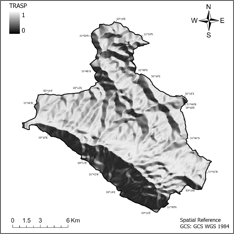
Derivation of primary geometric signatures including Slope gradient (G), Slope aspect (A), Northness, Eastness, and the TRASP index—fundamental metrics for modeling microclimate and potential solar irradiation.
Comprehensive extraction of surface curvatures: horizontal and vertical curvatures (controlling flow dynamics), Gaussian and mean curvatures (defining intrinsic surface form), alongside a full suite of advanced geometric metrics including maximal/minimal, horizontal/vertical excess, rotor, unsphericity, difference, accumulation, and ring curvatures.
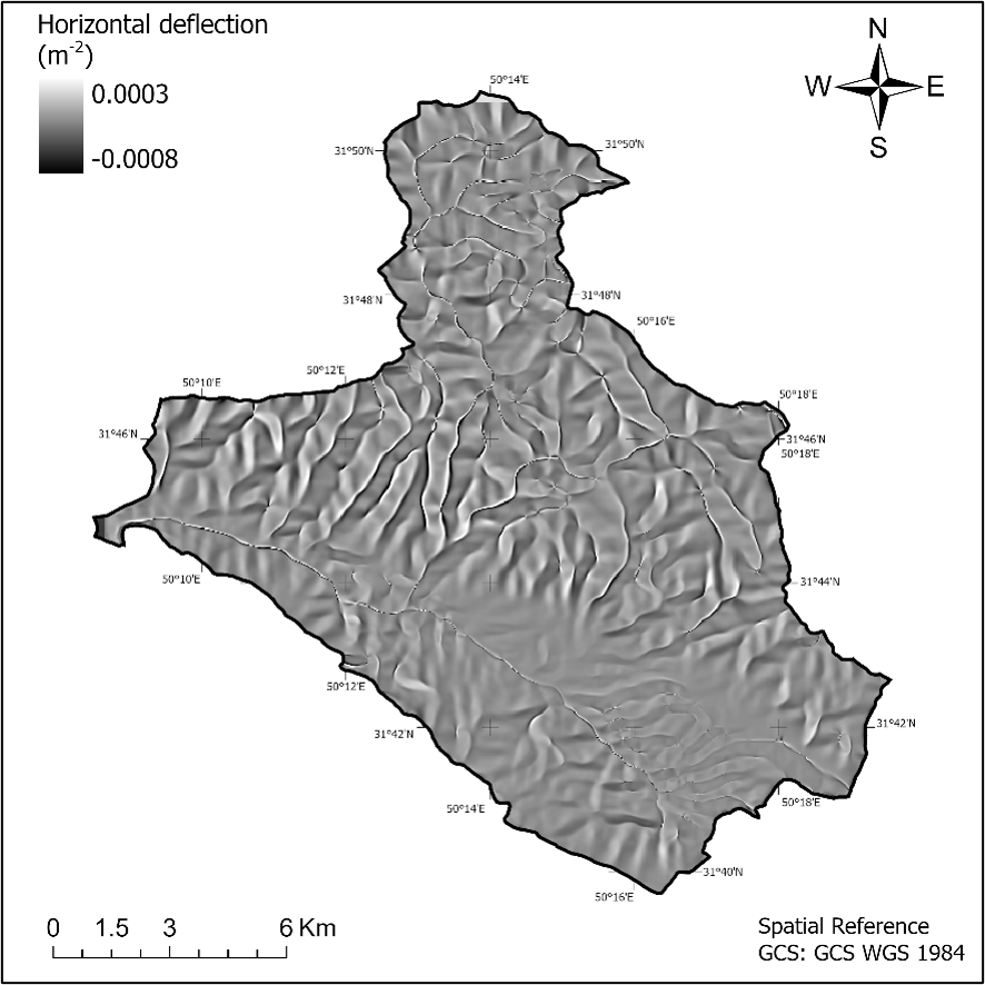
Computation of horizontal and vertical deflections, providing mathematically rigorous metrics for the precise spatial delineation of structural features such as thalwegs, crests, breaklines, and landslide crowns.
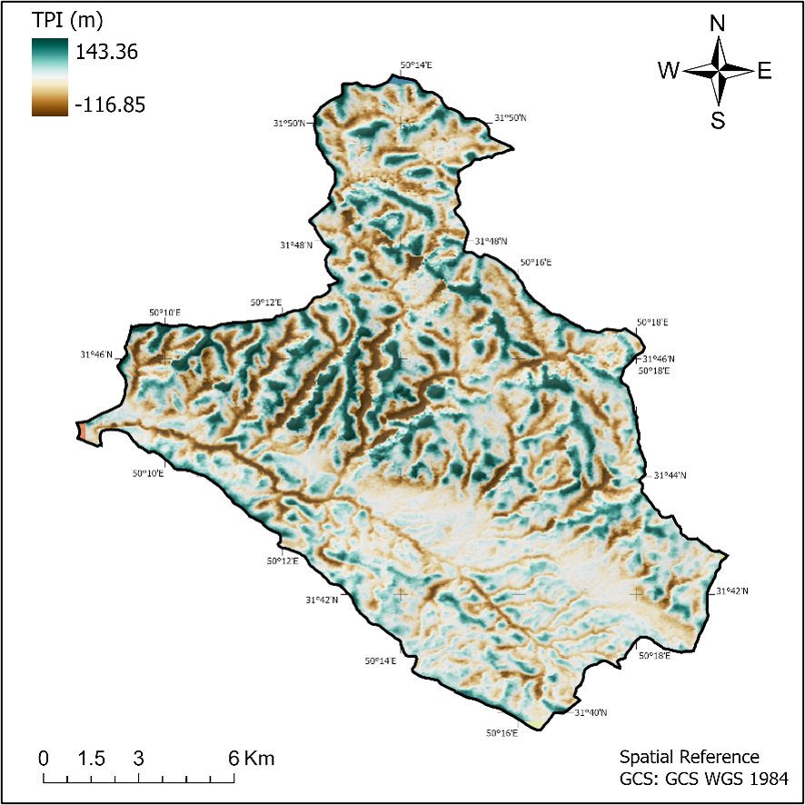
Quantifies the relative elevational deviation of a central grid cell from its local neighborhood mean. This context-dependent metric serves as the analytical foundation for the automated Weiss (2001) landform classification, enabling the robust spatial delineation of valleys, slopes, and ridges.
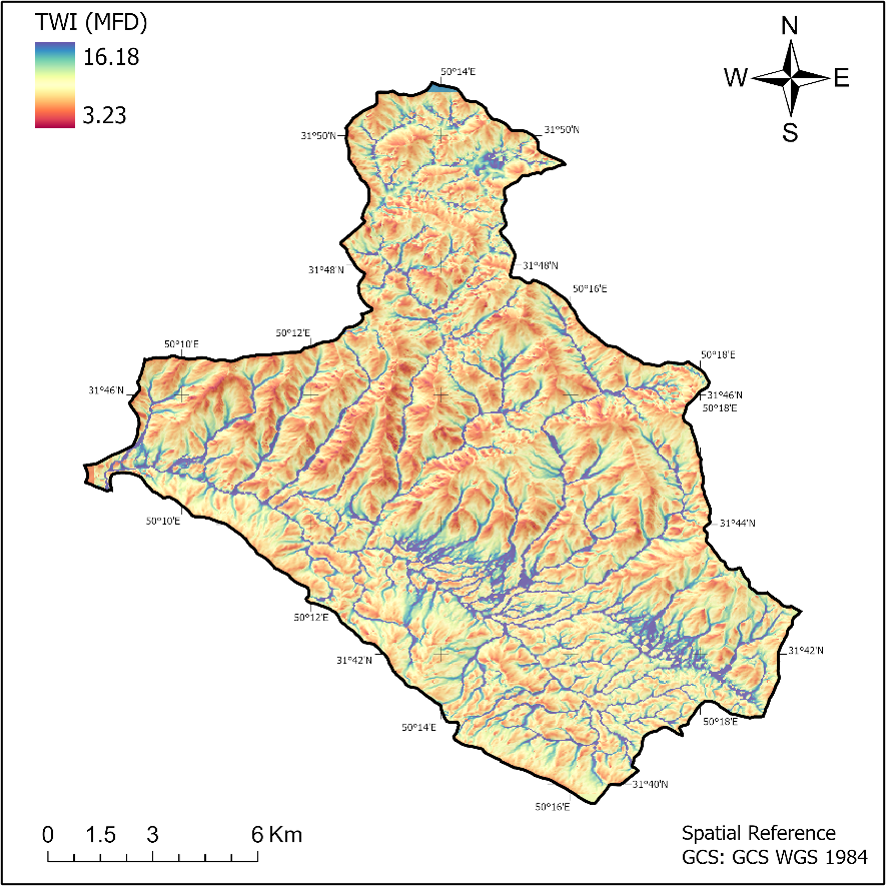
Computation of the Specific Catchment Area (SCA), Topographic Wetness Index (TWI), Stream Power Index (SPI), and the RUSLE Length-Slope (LS) factor. These fundamental hydro-geomorphic metrics are rigorously derived utilizing true spheroidal cell areas and dimensions, bypassing standard planar distortions.
Direct extraction of the foundational Taylor polynomial coefficients (p, q, r, s, t, g, h, k, m). This transparency grants advanced users and researchers the exact mathematical derivatives required to formulate, test, and validate custom geomorphometric models.
From Continuous Metrics to Categorical Delineation
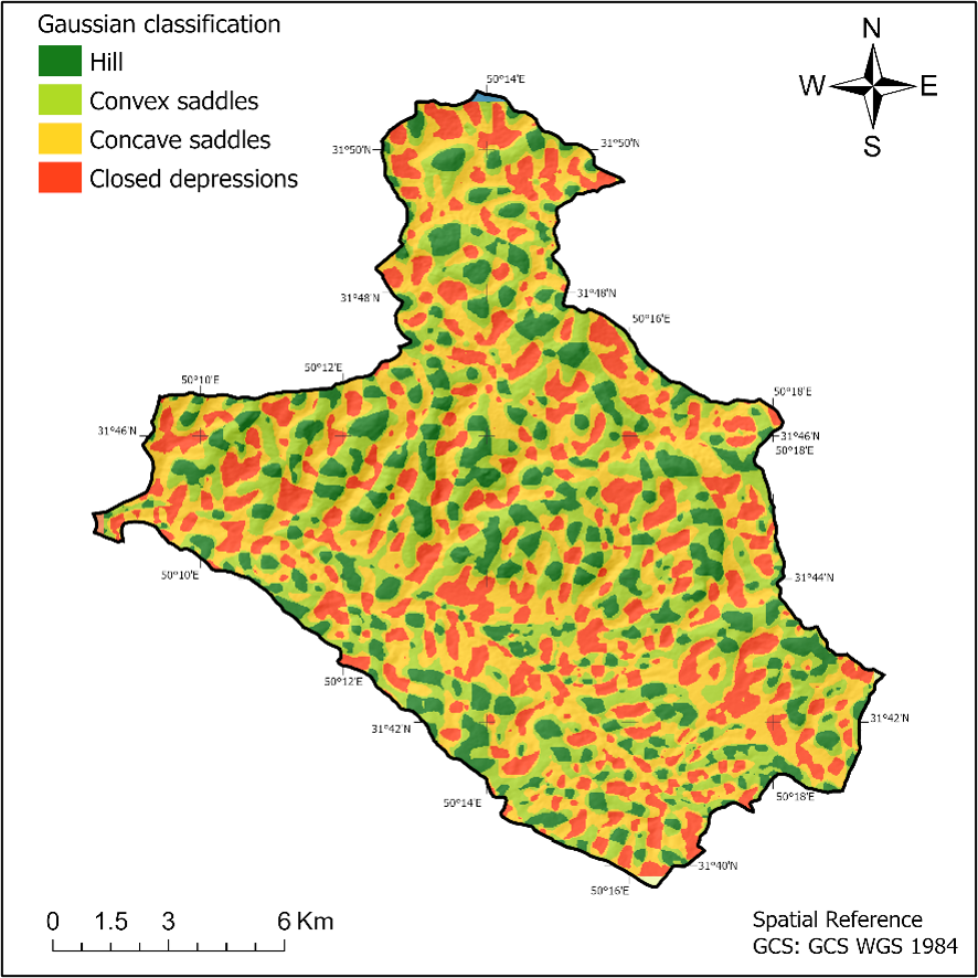
Translating continuous mathematical surfaces into discrete, semantically meaningful landform categories. The engine natively integrates four rigorous classification topologies: the Gaussian (8-class), Efremov-Krcho (9-class), Shary (12-class), and the TPI-based Weiss (6-class) systems.
Grounded in the fundamental principles of differential geometry (Gauss's Theorema Egregium), this system evaluates the signs of mean (H) and Gaussian (K) curvatures to mathematically segment the terrain into hills, ridges, valleys, closed depressions, saddles, and planar surfaces.
Rooted in the kinematics of gravitational mass movement, this topology leverages the interplay of horizontal and vertical curvatures to delineate zones of material accumulation, dissipation, and neutral transit.
Incorporates difference curvature (E) alongside H and K for the high-fidelity segmentation of hill, depression, and saddle sub-classes. This rigorous 13-class framework is highly optimized for detailed micro-topographic characterization.
Synthesizes the Topographic Position Index (TPI) standard deviation with local slope gradients. As an inherently scale-dependent method, it is exceptionally capable of isolating spatial features ranging from micro-scale channels to macro-structural valleys.
Output Gallery
Encompassing theoretical foundations, rigorous spheroidal differential geometry formulations, robust algorithmic implementation strategies, exact morphometric equations with academic interpretations, comprehensive I/O specifications, and step-by-step execution workflows for ArcGIS Pro—all consolidated into a definitive technical reference.
Terms of Use
Deployment and utilization of the Geomorphometry Toolbox (Version 1.0) are strictly governed by a formal collaboration framework. Access to the computational engine is exclusively contingent upon the establishment of joint scientific research initiatives, academic partnerships, or applied engineering projects.
Academic Publication
A comprehensive, peer-reviewed resource covering the theoretical foundations, local and regional morphometric variables, and practical applications of digital terrain analysis.
Authored by Dr. Javad Khanifar, this academic work provides an in-depth exploration of continuous surface modeling, flow-routing algorithms, and automated landform classification systems.
About the Developer
As an academic lecturer, researcher, and interdisciplinary specialist, Dr. Khanifar’s expertise encompasses soil science and engineering, geomorphometry, remote sensing, and artificial intelligence. His research is dedicated to the integration of cutting-edge technologies within the geosciences and agricultural engineering.
View Research ProfileGet in Touch
Have a question about the toolbox, or interested in a joint research initiative? Feel free to reach out directly via email.